Oslo
Oslo Neighborhoods: Where to Stay and What Each Area Is Like
Oslo’s inner neighborhoods are close together but quite different in character. This guide explains the historic center, modern waterfront, residential west, Grünerløkka and the inner east — including sights, transportation, evenings and the kinds of accommodation found in each area.
Practical Norway · Based in Oslo
Last reviewed: September 2026
Hotels, short-term rentals and transportation services change. Neighborhood descriptions here are intended for orientation; check the exact address and current transport connections before booking accommodation.
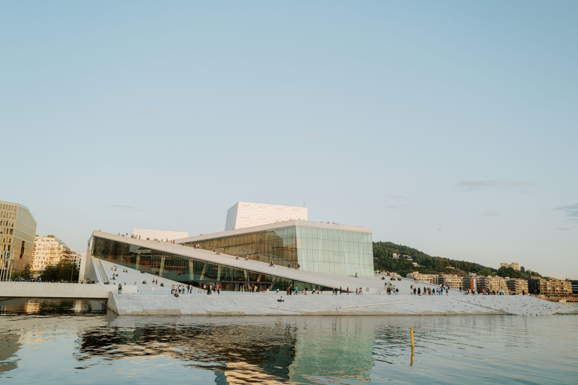
Oslo is compact and well connected, so there is no single “wrong” central neighborhood. The useful choice is what you want immediately outside the hotel: the easiest sightseeing logistics, Oslo S convenience, waterfront atmosphere, quieter residential streets, or restaurants and nightlife.
For most first-time visitors, Sentrum/Kvadraturen or Bjørvika are the simplest bases. Aker Brygge and Tjuvholmen trade some transport convenience for a polished waterfront setting; Frogner is quieter and more residential; Grünerløkka is strongest for restaurants, bars and neighborhood life.
The short answer
- Sentrum / Kvadraturen
- Best for a first visit when easy sightseeing logistics matter most.
- Bjørvika
- Best for Oslo S convenience and the modern waterfront.
- Aker Brygge / Tjuvholmen
- Best for polished waterfront atmosphere; usually more expensive.
- Frogner
- Best for a quieter, elegant residential feel.
- Grünerløkka
- Best for restaurants, bars and neighborhood energy, with less direct access to some headline sights.
Orientation
How Oslo’s inner city fits together
Oslo Central Station sits near the eastern end of the traditional center.
From there, Karl Johans gate runs west toward the Royal Palace, passing the commercial and civic heart of the city.
South of this axis is the harbor. Bjørvika occupies the eastern waterfront, while Akershus Fortress, City Hall, Aker Brygge and Tjuvholmen continue west along the shoreline.
Frogner and Majorstuen lie west and northwest of the center.
St. Hanshaugen lies north of the center, while Grünerløkka spreads northeast along the Akerselva corridor.
Immediately east of Oslo S are Grønland, Tøyen and the older districts of Gamle Oslo.
Most of these areas are separated by relatively short urban distances, and public transportation reduces the practical difference further.
Sentrum and Kvadraturen
Central Oslo stretches from the area around Oslo S west along Karl Johans gate toward the Royal Palace and south toward the harbor.
Within it, Kvadraturen is the historic street grid between Akershus Fortress and Karl Johans gate. The district dates from the rebuilding of Oslo in the 17th century and contains some of the oldest surviving buildings in the center.
The broader central area contains Parliament, Oslo Cathedral, the National Theatre, City Hall, Akershus Fortress, shopping streets, restaurants and many of the city’s principal hotels.
It is Oslo at its most urban: commercial during the day, busy around transportation hubs, and active into the evening around restaurants, bars and theaters.
Accommodation
Central Oslo has the city’s largest concentration of conventional hotels.
Properties range from large full-service hotels to smaller city hotels and budget accommodation, particularly around Oslo S, Karl Johans gate, Stortorvet and the Nationaltheatret area.
Apartment and short-term rental listings also exist, but hotels are a much more visible part of the accommodation landscape here than in Oslo’s primarily residential neighborhoods.
Transport
Oslo S is the city’s principal railway station and one of its main public-transport hubs.
Nationaltheatret provides another important rail and metro connection toward the western side of the center.
Trams, buses and metro lines cross the district frequently.
Nearby sights
Akershus Fortress · Karl Johans gate · Parliament · Oslo Cathedral · City Hall · Royal Palace · National Museum
Bjørvika
Bjørvika is the modern eastern waterfront immediately beside Oslo S.
For much of the 20th century, the district was dominated by port facilities, roads and rail infrastructure. Large-scale redevelopment moved major traffic underground and reopened the waterfront to pedestrians.
Today Bjørvika contains some of Oslo’s most prominent contemporary architecture.
The Opera House sits directly on the harbor. MUNCH rises nearby, while the Deichman Bjørvika library, Barcode towers, Bispevika and Sørenga extend the district east and south.
This is one of the clearest places in Oslo to see how dramatically the waterfront has changed in the last two decades.
Accommodation
Hotel accommodation is concentrated closest to Oslo S and the northern edge of Bjørvika.
Farther into Bispevika and Sørenga, the district becomes increasingly residential, with modern apartment buildings and a greater presence of apartment-style and short-term rental accommodation.
Transport
Oslo S makes Bjørvika exceptionally well connected to airport, regional and intercity rail.
Tram, bus and metro services converge nearby, while much of the historic center can be reached on foot along the waterfront or through the station area.
Nearby sights
Opera House · MUNCH · Deichman Bjørvika · harbor promenade · Medieval Park nearby
Aker Brygge and Tjuvholmen
Aker Brygge and Tjuvholmen form the western end of Oslo’s central waterfront.
Aker Brygge developed from the former shipyard area beside City Hall and is now a pedestrian district of restaurants, shops, offices and apartments.
A bridge continues to Tjuvholmen, a newer waterfront development built around residential architecture, public spaces, galleries and the Astrup Fearnley Museum.
The National Museum, City Hall and Nobel Peace Center are all close by.
In summer, the harbor promenade is one of the busiest public spaces in central Oslo. In colder months it is noticeably quieter, though restaurants and cultural institutions remain active.
Accommodation
The hotel inventory is smaller than in the traditional city center and includes some of Oslo’s more upscale properties.
Tjuvholmen is also heavily residential, so apartment-style accommodation and short-term rentals may appear alongside conventional hotels.
Availability changes and should not be characterized by fixed counts.
Transport
Trams and buses serve the western center, while Nationaltheatret is the principal nearby rail and metro station.
Oslo S lies farther east but remains reachable by public transportation or through the central pedestrian corridor.
Nearby sights
City Hall · National Museum · Nobel Peace Center · Astrup Fearnley Museum · harbor promenade
Frogner and Uranienborg
West of the Royal Palace, central Oslo gives way to broad residential streets, embassies and late-19th- and early-20th-century apartment buildings.
Frogner and neighboring Uranienborg represent much of the traditional residential west side of inner Oslo.
Bygdøy allé, Skovveien and the streets around Solli plass contain restaurants, cafés, shops and local services, while quieter residential blocks spread north and west.
Frogner Park and the Vigeland sculpture installation lie at the western edge of the inner district.
The overall character is more residential than Sentrum or Grünerløkka, although the streets closest to Solli, Hegdehaugsveien and Bogstadveien remain active commercial areas.
Accommodation
Accommodation is more dispersed than in Sentrum.
Smaller hotels, apartment hotels and serviced apartments appear along the main streets and closer to the center, while conventional hotel supply becomes thinner deeper into the residential neighborhoods.
Short-term apartment rentals are also part of the accommodation mix.
Transport
Trams and buses connect Frogner with the city center.
The exact location matters because Frogner covers a substantial area: a property near Solli plass functions differently from one beside Frogner Park.
Nearby sights
Vigeland Sculpture Park · Vigeland Museum · Frogner Park · Royal Palace area
Majorstuen
Majorstuen sits north of Frogner and marks one of western Oslo’s principal transport and shopping centers.
Bogstadveien and Hegdehaugsveien form a long commercial corridor connecting Majorstuen with the Royal Palace area.
The neighborhood itself mixes apartment buildings, shops, restaurants and busy transportation streets.
Frogner Park lies within walking distance to the southwest, while the metro provides quick access both to the center and to the hills and forests farther west and north.
Majorstuen feels more like an everyday urban district than a sightseeing center, despite its proximity to Vigeland Park.
Accommodation
Hotel supply is smaller than in Sentrum.
The area contains a mix of conventional lodging, apartment-style accommodation and short-term rentals within the surrounding residential streets.
Transport
Majorstuen is one of Oslo’s most useful public-transport interchanges, with metro, tram and bus connections.
This gives the area a much larger practical reach than its distance from the harbor might suggest.
Nearby sights
Vigeland Park · Bogstadveien · western Oslo neighborhoods
Grünerløkka
Grünerløkka developed rapidly during Oslo’s 19th-century industrial expansion.
Factories and workshops lined the nearby Akerselva, and the surrounding apartment districts housed much of the city’s industrial working population.
The neighborhood has changed substantially, but its older apartment blocks and industrial buildings remain a visible part of the streetscape.
Today Thorvald Meyers gate, Markveien, Olaf Ryes plass and Birkelunden form the center of a dense restaurant, café, bar and independent-shop district.
Along the Akerselva, former industrial buildings have been converted to cultural, restaurant and commercial uses. Mathallen occupies one of these redeveloped areas near the river.
Grünerløkka has a noticeably different evening rhythm from residential Frogner or the waterfront districts, with restaurants and bars spread through the neighborhood rather than concentrated in a single complex.
Accommodation
There are fewer large conventional hotels inside Grünerløkka than in central Oslo.
Smaller properties, hostels, apartment accommodation and short-term rentals appear in and around the district, particularly toward its lower end and the boundary with the center.
Transport
Trams and buses provide the principal connections with central Oslo.
The lower part of Grünerløkka is also within walking distance of the center, while the northern end requires more regular use of public transportation.
Nearby sights
Akerselva · Mathallen · Birkelunden · Olaf Ryes plass · independent shops and restaurants
St. Hanshaugen and Bislett
St. Hanshaugen occupies the higher ground immediately north of central Oslo.
The neighborhood takes its name from the large hilltop park, which provides views over the city and fjord.
To the west is Bislett, known internationally for Bislett Stadium but otherwise primarily a residential inner-city district.
These neighborhoods contain apartment buildings, cafés, restaurants, schools and local shopping rather than major concentrations of visitor attractions.
They remain close to the center but feel less shaped by tourism than the harbor and Karl Johans gate.
Accommodation
Large hotels are relatively uncommon compared with Sentrum.
Apartment-style accommodation, smaller lodging properties and short-term rentals make up a larger share of what visitors encounter in these residential districts.
Transport
Buses provide important connections through St. Hanshaugen, while trams serve parts of the surrounding area.
Many central sights remain within a reasonable urban walk, depending on the exact address.
Nearby sights
St. Hanshaugen park · Bislett Stadium · cafés and residential streets
Grønland, Tøyen and Gamle Oslo
Immediately east of Oslo S, the character of the city changes quickly.
Grønland is one of Oslo’s most culturally diverse commercial districts, with restaurants, grocery shops and businesses representing communities from many parts of the world.
Farther east, Tøyen contains the Botanical Garden, Natural History Museum and residential streets surrounding Tøyen square.
To the south and southeast are Gamlebyen and the remains of medieval Oslo, close to the area where the original city developed before it was relocated after the fire of 1624.
This part of Oslo combines some of the city’s oldest history with its most diverse contemporary neighborhoods.
The street environment around Grønland is busier and more intensely urban than Frogner, St. Hanshaugen or the quieter residential west.
Accommodation
Conventional hotels are more concentrated toward Grønland, the bus terminal and the Oslo S edge of the district.
Farther into Tøyen and the residential parts of Gamle Oslo, apartment accommodation and short-term rentals are more typical than large visitor hotels.
Transport
Grønland and Tøyen have metro stations, while buses and other local services connect the wider area.
Oslo S is immediately west of Grønland, giving parts of the district unusually good access to intercity and airport rail despite their more residential character.
Nearby sights
Botanical Garden · Natural History Museum · medieval Oslo · Grønland · Ekeberg nearby
Other areas worth knowing
Bygdøy
Bygdøy is the museum peninsula west of central Oslo. The Fram Museum, Kon-Tiki Museum, Norwegian Maritime Museum and Norsk Folkemuseum are located here. Much of the peninsula is residential, and it functions primarily as a sightseeing destination rather than one of Oslo’s main hotel districts. Public buses operate year-round, while seasonal passenger boats may also connect the peninsula with the central harbor.
Ekeberg
Ekeberg rises southeast of the center above Bjørvika and Gamle Oslo. The hillside contains Ekebergparken, woodland, residential areas and wide views over the harbor. It is easy to visit from central Oslo but is not part of the dense central accommodation corridor.
Holmenkollen
Holmenkollen lies in the wooded hills northwest of central Oslo. The ski jump and Ski Museum are the best-known visitor sights, while nearby districts are primarily residential and recreational. Metro service connects Holmenkollen with the center.
Accommodation
How accommodation is distributed across Oslo
Oslo’s accommodation changes noticeably from one district to another.
Traditional hotels are most concentrated in and around the city center, particularly between Oslo S, Karl Johans gate and the western central area around Nationaltheatret.
The waterfront districts contain a mixture of hotels and newer residential development.
In Frogner, Grünerløkka, St. Hanshaugen and the inner east, accommodation becomes more dispersed. Smaller hotels, serviced apartments and short-term apartment rentals appear among ordinary residential buildings rather than forming a dedicated visitor district.
This distinction matters because an apartment address can place a visitor much deeper inside a neighborhood than a conventional hotel address.
Short-term-rental inventory changes constantly. No fixed count reliably describes a neighborhood.
The exact address matters more than the neighborhood label
Neighborhood names in hotel and rental listings can be broad.
Two properties described as being in Frogner or Grünerløkka may have meaningfully different transportation and walking patterns.
Before booking, check:
- the exact street
- the nearest tram, metro or bus stop
- the route from Oslo S or Nationaltheatret
- the distance to the sights most important to the trip
- whether luggage requires a transfer
- whether the immediate street has significant nightlife
- accessibility requirements such as elevators, steps and steep approaches
Oslo S and Nationaltheatret
Oslo S is the city’s principal railway station and sits between the traditional center and Bjørvika.
Nationaltheatret station lies underground near the Royal Palace and western side of the center.
Many local, regional and airport trains serve both stations, although the exact stopping pattern varies by service.
This means accommodation does not need to be beside Oslo S to have useful rail access.
For a specific airport or intercity departure, verify which station the service uses before relying on Nationaltheatret as an alternative.
Public transportation makes Oslo’s neighborhoods easy to combine
Oslo’s metro, tram, bus and local ferry system connects the inner neighborhoods closely.
For visitors, the practical value of an address often depends as much on its nearest public-transport stop as on straight-line distance from the center.
Majorstuen, for example, lies well west of the harbor but functions as a major metro and tram interchange.
Grünerløkka has no intercity railway station but is closely connected to the center by tram and bus.
Tøyen and Grønland sit east of the traditional center but have direct metro access.
Verify current information
Neighborhood character changes gradually, while transport services and visitor information change more frequently.
Use these official sources to confirm current connections, airport transportation and area information before booking.
- VisitOSLO — Explore Oslo’s neighborhoods (opens in a new tab)
- Visitor-oriented neighborhood overview and map context.
- VisitOSLO — City centre (opens in a new tab)
- Current visitor information for central Oslo and Kvadraturen.
- VisitOSLO — Bjørvika/Oslobukta (opens in a new tab)
- Current visitor information for the eastern waterfront.
- VisitOSLO — Aker Brygge and Tjuvholmen (opens in a new tab)
- Current visitor information for the western waterfront.
- VisitOSLO — Grünerløkka (opens in a new tab)
- Current area information for Grünerløkka and the Akerselva corridor.
- VisitOSLO — Oslo West (opens in a new tab)
- Current visitor information for Frogner, Majorstuen, St. Hanshaugen and Bislett.
- VisitOSLO — Oslo East (opens in a new tab)
- Current visitor information for Grønland, Tøyen and eastern Oslo.
- Oslo kommune — St. Hanshaugen park (opens in a new tab)
- Official municipal park information.
- Ruter (opens in a new tab)
- Current metro, tram, bus and local ferry information.
- Entur (opens in a new tab)
- Current public-transport journey planning across Norway.
- Avinor — Oslo Airport (opens in a new tab)
- Current ground-transport information for Oslo Airport.